Tampilkan postingan dengan label science. Tampilkan semua postingan

Jumat, 28 Agustus 2009

Natural Gas Shales


Background - Gas Shales Haynesville Shale Map
Haynesville Shale: News, videos & information for the Haynesville Shale in northern Louisiana and adjacent state

The first commercial natural gas well in the United States was drilled in 1821 in Fredonia, New York. It produced gas from organic-rich Devonian-age shale. Since then many other wells have produced natural gas from shale. However, shale is most commonly thought of as a natural gas source rock rather than as the target of drilling activity.

In the late 1990s improved drilling and well stimulation methods were developed for the Barnett Shale of Texas which significantly increased the yield and recovery rate of natural gas from a shale. These methods are now being applied in many parts of the United States. The result has been nothing less than a boom in natural gas leasing and production activity. The maps on these pages connect you to information about several of the new gas plays.


Barnett Shale Map
Barnett Shale: The recent boom in unconventional natural gas drilling started in Texas with the Barnett Shale.


Fayetteville Shale
Fayetteville Shale Map Fayetteville Shale: Another huge natural gas field is discovered in northern Arkansas. Some think it might be 4th largest gas reservoir in the world.

Mineral Rights
Mineral Rights / Surface Rights: Who owns the minerals under your land? Have they been sold?

Map of Marcellus Shale Marcellus Shale: Some people believe that before 2008, the Marcellus was the most overlooked resource in the eastern US!
Continue Reading...

Kamis, 27 Agustus 2009

The Pacific Ocean Tsunami Threat is Higher Than Expected

Tsunami mapTravel time map for a tsunami triggered by a subduction zone earthquake off the southern coast of Alaska. Each color band is a one-hour travel time increment. Image by NOAA. Enlarge Map


Tsunami inundation
Coastal inundation at Valdez, Alaska caused by the March 28, 1964 Gulf of Alaska Tsunami. Image by NOAA. Enlarge Image

Tsunami damage
Damage at the port of Seward, Alaska caused by the March 28, 1964 Gulf of Alaska Tsunami. Image by NOAA. Enlarge Image


Potential of Future Tsunamis


The potential for a huge Pacific Ocean tsunami on the West Coast of North America may be greater than previously thought.

The new study of geological evidence along the Gulf of Alaska coast suggests that future tsunamis could reach a scale far beyond that suffered in the tsunami generated by the great 1964 Alaskan earthquake. Official figures put the number of deaths caused by the earthquake at around 130: 114 in Alaska and 16 in Oregon and California. The tsunami killed 35 people directly and caused extensive damage in Alaska, British Columbia, and the US Pacific region*.

The 1964 Alaskan earthquake – the second biggest recorded in history with a magnitude of 9.2 – triggered a series of massive waves with run up heights of as much as 12.7 metres in the Alaskan Gulf region and 52 metres in the Shoup Bay submarine slide in Valdez Arm.

The study suggests that rupture of an even larger area than the 1964 rupture zone could create an even bigger tsunami. Warning systems are in place on the west coast of North America but the findings suggest a need for a review of evacuation plans in the region.


Evaluation of Ancient Earthquakes


The research team from Durham University in the UK, the University of Utah and Plafker Geohazard Consultants, gauged the extent of earthquakes over the last 2,000 years by studying subsoil samples and sediment sequences at sites along the Alaskan coast. The team radiocarbon-dated peat layers and sediments, and analysed the distribution of mud, sand and peat within them. The results suggest that earthquakes in the region may rupture even larger segments of the coast and sea floor than was previously thought.

The study published in the academic journal Quaternary Science Reviews and funded by the National Science Foundation, NASA, and the US Geological Survey shows that the potential impact in terms of tsunami generation, could be significantly greater if both the 800-km-long 1964 segment and the 250-km-long adjacent Yakataga segment to the east were to rupture simultaneously.


Larger Ancient Earthquakes


Lead author, Professor Ian Shennan, from Durham University’s Geography Department said: "Our radiocarbon-dated samples suggest that previous earthquakes were fifteen per cent bigger in terms of the area affected than the 1964 event. This historical evidence of widespread, simultaneous plate rupturing within the Alaskan region has significant implications for the tsunami potential of the Gulf of Alaska and the Pacific region as a whole."

"Peat layers provide a clear picture of what’s happened to the Earth. Our data indicate that two major earthquakes have struck Alaska in the last 1,500 years and our findings show that a bigger earthquake and a more destructive tsunami than the 1964 event are possible in the future. The region has been hit by large single event earthquakes and tsunamis before, and our evidence indicates that multiple and more extensive ruptures can happen."


Causes of a Tsunami


Tsunamis can be created by the rapid displacement of water when the sea floor lifts and/or falls due to crustal movements that accompany very large earthquakes. The shallow nature of the sea floor off the coast of Alaska could increase the destructive potential of a tsunami wave in the Pacific.


Earthquake behaviour is difficult to predict in this region which is a transition zone between two of the world's most active plate boundary faults; the Fairweather fault, and the Aleutian subduction zone. In 1899 and 1979, large earthquakes occurred in the region but did not trigger a Tsunami because the rupturing was localized beneath the land instead of the sea floor.

Prof Ron Bruhn from the University of Utah said: "If the larger earthquake that is suggested by our work hits the region, the size of the potential tsunami could be signficantly larger than in 1964 because a multi-rupture quake would displace the shallow continental shelf of the Yakutat microplate."

"In the case of a multi-rupture event, the energy imparted to the tsunami will be larger but spread out over a longer strike distance. Except for the small communities at the tsunami source in Alaska, the longer length will have more of an effect on areas farther from the source such as southeastern Alaska, British Columbia, and the US west coast from Washington to California."


Tsunami Warning Systems


Warning systems have been in place on the US western seaboard and Hawaii since the 1946 Aleutian Islands tsunami. Improvements were made following the 2004 earthquake under the Indian Ocean that triggered the most deadly tsunami in recorded history, killing more than 230,000 people.

A tsunami triggered by an Alaska earthquake could cause damage around the Pacific


Prof Shennan said: "Earthquakes can hit at any time of the day or night, and that’s a big challenge for emergency planners. A tsunami in this region could cause damage and threaten life from Alaska to California and beyond; in 1964 the effects of the tsunami waves were felt as far away as southern California and were recorded on tide gages throughout the Pacific Ocean."

Dr George Plafker from Plafker Geohazard Consultants said: "A large scale earthquake will not necessarily create a large wave. Tsunami height is a function of bathymetry, and the amount of slip and dip of the faults that take up the displacement, and all these factors can vary greatly along the strike."

"Tsunamis will occur in the future. There are issues in warning and evacuating large numbers of people in coastal communities quickly and safely. The US has excellent warning systems in place but awareness is vital."
Continue Reading...

Drilling to Earth's Mantle May Now Be Possible

Zero discharge drilling One problem with drilling deep holes in ultra-deepwater is the control and recirculation of drilling mud that cools the drilling process and flushs rock cuttings out of the drill hole. In the riserless mud recovery system, drilling mud is pumped down the drill pipe, exits through the drill bit, returns to the top of the hole outside of the drill pipe and is then captured as it exits the hole and pumped back to the surface through a rigid mud return line. Image by the Integrated Ocean Drilling Program. Enlarge Image

Technology for Drilling to the Moho


The Integrated Ocean Drilling Program (IODP), in collaboration with industry partner AGR Drilling Services, has engineered an ultra-deepwater drilling technology for use by IODP drilling vessels in scientific research.

Originally developed for shallow-water oil and gas exploration, the "riserless mud recovery" technology (RMR™) holds great promise for scientists striving to reach the long-held goal of Project Mohole in the 1950s: drilling all the way through ocean crust into the Earth’s mantle; a frontier not yet explored today. Drilled cores from the mantle could provide scientists with answers to questions about the structure, composition, mineralogy, and in situ physical properties of oceanic crust and the geological nature of the seismic Moho.

Implementation As Early As July, 2011


"With AGR Drilling Services’ support, IODP led an engineering effort to adapt existing technology to drill very deep holes in very deep regions of the ocean," says Engineering Manager Greg Myers. "Up to now, riserless mud recovery drilling was limited to shallower water depths.

This ultra-deepwater drilling technology allows scientists to investigate subseafloor areas in great depths, where oceanic crust may be thinner—such as in waters off Hawaii." According to Myers, an ultra-deepwater RMR™ system could be implemented as early as July 2011.

The RMR™ technology, owned by AGR, is expected to operate in hyper-deepwater depths greater than 12,000 feet. Funding for preliminary engineering was provided by the DeepStar Consortium, a deepwater industry group that supports deepwater technology development projects and leverages the industry’s financial and technical resources.

"This ultra-deepwater drilling technology is environmentally friendly," says David Hine, AGR Vice President of Sales and Marketing. "It operates with a 'zero-discharge' system, leaving no cuttings or mud behind."

Previous Near-Mantle Depth Drilling


In December 2005, scientists aboard IODP Expedition 312 approached mantle depths while drilling to investigate superfast seafloor spreading rates. The research expedition penetrated volcanic rock (gabbros) and reached a fossil magma chamber lying 1.4 kilometers beneath the seafloor. The Moho, or mantle, lies beneath the gabbros layer of ocean crust at depths that vary from about 5-10 km. beneath the ocean floor, to about 40 km. beneath the continents, to as much as 70 km. beneath some mountain ranges.
The Integrated Ocean Drilling Program (IODP) is an international marine research program led by the National Science Foundation in the U.S. with support from another 23 countries. IODP advances scientific understanding of Earth by drilling, sampling, and monitoring subseafloor environments.

Using multiple platforms and technologies, the world’s preeminent scientists working in the program explore climate change, the deep biosphere, and geodynamics.

Republished from a press release from the Integrated Ocean Drilling Program issued in August, 2009.
Continue Reading...

Senin, 17 Agustus 2009

Meteorites on Mars

Meteorites on Mars

NASA's Mars Rovers Are Great For Finding Meteorites!


Hard to Find on Earth but Abundant on Mars?


NASA's two Mars Rovers have found some spectacular meteorites. On Earth, the only humans who are as successful at finding meteorites are professional meteorite hunters. Are meteorites that abundant on Mars or are these Rovers simply lucky?

The answer to this question has a lot to do with the environment of the two planets. The surface of Earth has an environment that is rich in oxygen and moisture - both of which are rapidly destructive to iron meteorites. A meteorite that lands on Earth's surface would rust away in a blink of geologic time. Mars, however, has very little oxygen and moisture in its atmosphere and surface soils. Meteorites that land on Mars can remain in excellent condition for millions - or even billions - of years. Mars is the perfect place to hunt for meteorites.

Mars Meteorite: Block Island

Mars Meteorite
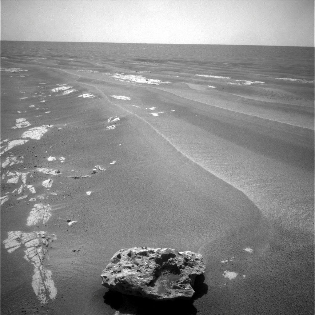
This is a picture of "Block Island," the largest meteorite yet to be found on Mars. It is about 60 centimeters across (about 2 feet) and is estimated to weigh about one-half ton. Analysis of its composition by Rover Opportunity's alpha particle X-ray spectrophotometer reveals that it is rich in iron and nickel - proof positive that it is an iron meteorite. This photo was taken by the navigation camera on NASA’s Mars Exploration Rover Opportunity on July 28, 2009.

The Mars Rover drove right past the rock but NASA researchers noticed it a few days later in an image that was taken and transmitted down to Earth. So they sent Opportunity back to check out the rock and touch it with its robotic arm for an analysis. Enlarge.

Mars Meteorite: Heat Shield Rock

Mars meteorite
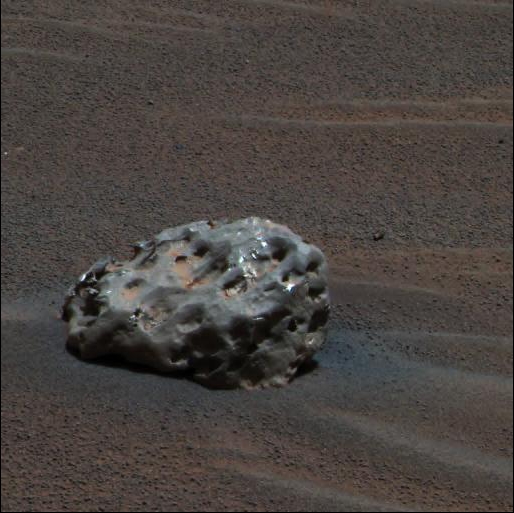
"Heat Shield Rock" is the first meteorite ever identified on the surface of another planet. It is a baseball-size iron-nickel meteorite discovered by NASA's Mars Exploration Rover Opportunity ON January 6, 2005. Its composition and identity as a meteorite were confirmed by the Rover's spectrophotometer - it determined that "Heat Shield Rock" was composed of iron and nickel. The Meteoritical Society originally named it "Meridiani Planum" after the location where it was found - this is the traditional naming convention for meteorites found on Earth. However, the name "Heat Shield Rock" has become more popular. It received that name because it was discovered near the location where Opportunity discarded its heat shield. How long the meteorite has been on the surface of Mars is unknown, however, it shows very little sign of rusting or other alteration. Enlarge Image.

Continue Reading...

Minggu, 16 Agustus 2009

What is Earth Science?


Introduction


Earth Science is the study of the Earth and its neighbors in space. It is an exciting science with many interesting and practical applications. Some Earth scientists use their knowledge of the Earth to locate and develop energy and mineral resources. Others study the impact of human activity on Earth's environment and design methods to protect the planet. Some use their knowledge about Earth processes such as volcanoes, earthquakes and hurricanes to plan communities that will not expose people to these dangerous events.


The Four Earth Sciences


Many different sciences are used to learn about the earth, however, the four basic areas of Earth science study are: geology, meteorology, oceanography and astronomy. A brief explanation of these sciences is provided below.


Geology: Science of the Earth


Geology is the primary Earth science. The word means "study of the Earth". Geology deals with the composition of Earth materials, Earth structures, and Earth processes. It is also concerned with the organisms of the planet and how the planet has changed over time. Geologists search for fuels and minerals, study natural hazards, and work to protect Earth's environment.


Meteorology: Science of the Atmosphere


Meteorology is the study of the atmosphere and how processes in the atmosphere determine Earth's weather and climate. Meteorology is a very practical science because everyone is concerned about the weather. How climate changes over time in response to the actions of people is a topic of urgent worldwide concern. The study of meteorology is of critical concern for protecting Earth's environment.


Oceanography: Science of the Oceans


Oceanography is the study of Earth's oceans - their composition, movement, organisms and processes. The oceans cover most of our planet and are important resources for food and other commodities. They are increasingly being used as an energy source. The oceans also have a major influence on the weather and changes in the oceans can drive or moderate climate change. Oceanographers work to develop the ocean as a resource and protect it from human impact. The goal is to utilize the oceans while minimizing the effects of our actions.


Astronomy: Science of the Universe


Astronomy is the study of the universe. Here are some examples of why studying space beyond Earth is important: the moon drives the ocean's tidal system, asteroid impacts have repeatedly devastated Earth's inhabitants and energy from the sun drives our weather and climates. A knowledge of astronomy is essential to understanding the Earth. Astronomers can also use a knowledge of Earth materials, processes and history to understand other planets - even those outside of our own solar system.


The Importance of Earth Science


Today we live in a time when the Earth and its inhabitants face many challenges. Our climate is changing and that change is being caused by human activity. Earth scientists recognized this problem and will play a key role in efforts to resolve it. We are also challenged to: develop new sources of energy that will have minimal impact on climate; locate new sources of metals and other mineral resources as known sources are depleted; and, determine how Earth's increasing population can live and avoid serious threats such as volcanic activity, earthquakes, landslides, floods and more. These are just a few of the problems where solutions depend upon a deep understanding of Earth science.
Continue Reading...

What is Geology?


What is Geology? - What Does a Geologist Do?


Definition of Geology:


Geology is the study of the Earth, the materials of which it is made, the structure of those materials, and the processes acting upon them. It includes the study of organisms that have inhabited our planet. An important part of geology is the study of how Earth’s materials, structures, processes and organisms have changed over time.


What Does a Geologist Do?


Geologists work to understand the history of our planet. The better they can understand Earth’s history the better they can foresee how events and processes of the past might influence the future. Here are some examples:

Geologists study earth processes: Many processes such as landslides, earthquakes, floods and volcanic eruptions can be hazardous to people. Geologists work to understand these processes well enough to avoid building important structures where they might be damaged. If geologists can prepare maps of areas that have flooded in the past they can prepare maps of areas that might be flooded in the future. These maps can be used to guide the development of communities and determine where flood protection or flood insurance is needed.

Geologists study earth materials: People use earth materials every day. They use oil that is produced from wells, metals that are produced from mines, and water that has been drawn from streams or from underground. Geologists conduct studies that locate rocks that contain important metals, plan the mines that produce them and the methods used to remove the metals from the rocks. They do similar work to locate and produce oil, natural gas and ground water.

Geologists study earth history: Today we are concerned about climate change. Many geologists are working to learn about the past climates of earth and how they have changed across time. This information is valuable to understand how our current climate is changing and what the results might be.


Geology as a Career:


Geology can be a very interesting and rewarding career. The minimum training required is a four-year college degree in geology. Pre-college students who are interested in becoming geologists should take a full curriculum of college preparatory courses, especially those in math, science, and writing. Courses related to computers, geography and communication are also valuable. Geologists work in a variety of settings. These include: natural resource companies, environmental consulting companies, government agencies, non-profit organizations, and universities. Many geologists do field work at least part of the time. Others spend their time in laboratories, classrooms or offices. All geologists prepare reports, do calculations and use computers.
Although a bachelor's degree is required for entry level employment,
many geologists earn master's and/or doctorate degrees. The advanced degrees provide a higher level of training, often in a geology specialty area such as paleontology, mineralogy, hydrology or volcanology. Advanced degrees will often qualify the geologist for supervisory positions, research assignments or teaching positions at the university level. These are some of the most sought after jobs in the field of geology.

Employment opportunities for geologists are very good. Most geology graduates with a strong academic background and good grades have no trouble finding employment if they are willing to move to a location where work is available.


Employment Outlook:


Over the next several years the number of geology job openings is expected to exceed the number of students graduating from university geology programs. Starting salaries for geologists have recently ranged from $50,000 to $100,000 per year.


How Can You Become a Geologist?


If you are a pre-college student can prepare to become a geologist by doing well in all of your courses. Science courses are especially important but math, writing, and other disciplines are used by every geologist during every working day.

If you are considering college or graduate school there are many universities that offer courses or programs in geology. Visit the website of a school that offers a geology degree, get in touch with the geology department, let them know you are interested and make arrangements to visit the campus. Don't be hesitant. Good schools and professors want to be contacted by interested students.

Continue Reading...
 

Sponsor

Info Bussiness

Science Bisnis Copyright © 2009 WoodMag is Designed by Ipietoon for Free Blogger Template